Français
  English
 Green Light Optimal Speed Advice
GLOSA is a traffic service allowing you to adapt your driving according to the state of traffic lights.
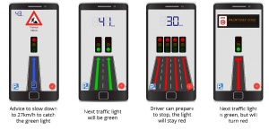
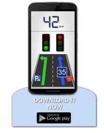
GLOSA is an innovative service, indicating to the driver the optimal speed to adopt to catch the green traffic light, and so not to stop. The functioning is simple: GLOSA service allows to warn the driver of the presence of a crossroads with traffic lights when he is at around 500 meters from it. It supplied in advance the number of traffic lanes, the available directions for each, as well as the state of the traffic light for every lane. If the traffic light is red and that it will pass to the green, GLOSA can advise the driver to slow down to adopt a certain speed to arrive at the crossroads when the light will pass to the green.
Thanks to NeoGLS team, this service is presently available through an intuitive application for Android smartphone.
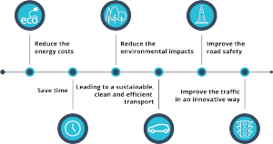
GlOSA service is available on your Android smartphone though an intuitive and ergonomic application, developed and installed by our teams. You just have to launch the application which will geo-locate you throughout your trip and will advise to you on the optimal speed to adopt to make it fastest, while being more secured and by reducing the energy costs of your vehicle.
Objectives of this service:
The different steps of GLOSA service deployment:
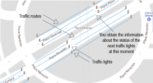
Two sources of standardized data are essential in the proper functioning of the GLOSA solution:
- The cartography of the intersection (MAP): this device allows to obtain traffic lanes used by the driver. That is to say that it allows to the GLOSA application to determine when the driver arrives near a traffic lights zone, and especially to know which of them are concerned.
NeoGLS generates the cartography from the data transmitted by the centralization system of the traffic lights of the concerned city (Gertrude in Bordeaux), by retranscribing them on our input tool. These data include the identifiers of all the traffic lights, the speed limit of the traffic lanes and the possible actions (turn left, turn right, continue straight).
- The state of traffic lights (SPAT): this device allows to know the color of the traffic lights at a specific point in time (red, orange, green) and the exact duration of their state.
There are 2 different ways to get the data of the state of the traffic lights (SPAT): directly by the local controllers of traffic lights and by systems of centralized management of traffic lights. These two devices transmit the data concerning the state of the traffic lights according to their identifier, either to the RSU (Road Side Unit), or directly to the application, or to a hybrid solution of these two cases.
We propose 3 different solutions of deployment:
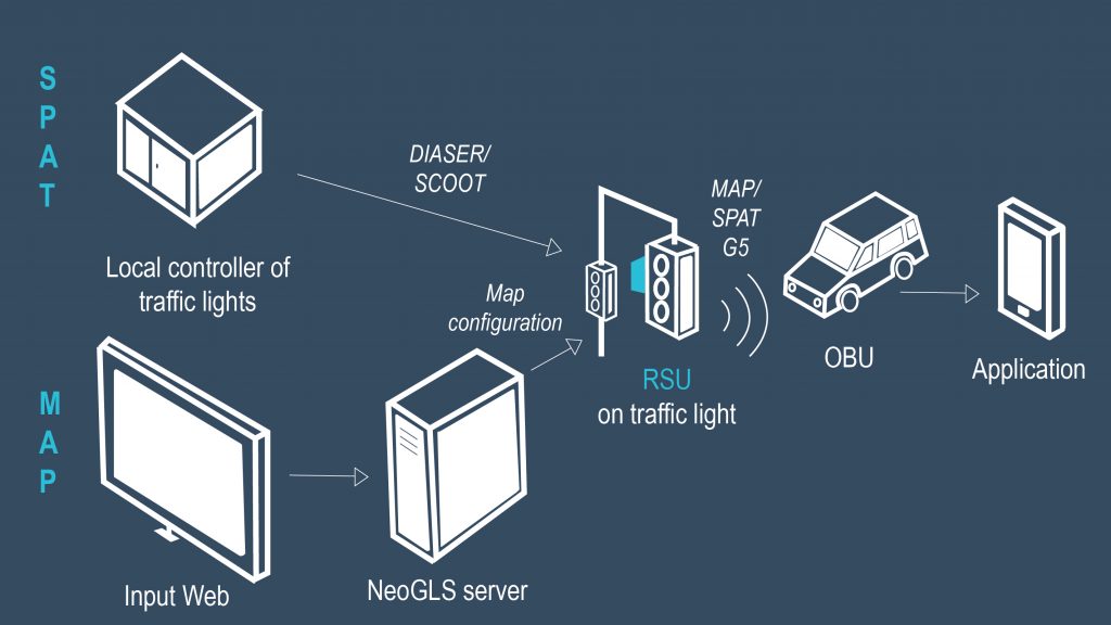
Solution 1:
- NeoGLS proceeds to the seizure of the map on the server by using the Web-based interface.
- The server sends the map to the RSU (Road Side Unit), situated on an existing traffic light, which also receives the data concerning the current state of the traffic lights (color and duration), from the local controller of traffic lights.
- The RSU diffuses the information (SPAT + MAP) by wireless network G5 (WiFi-P).
- The OBU (On Board Unit) receives these data and transmits them to the Android application.
- Then, the application advises the driver.
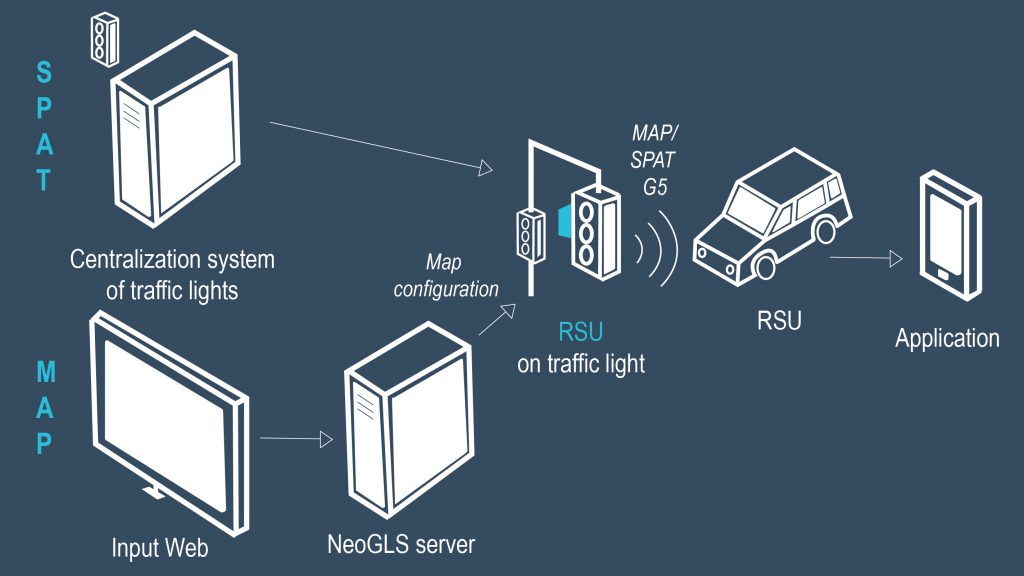
Solution 2:
- NeoGLS proceeds to the seizure of the map on the server by using the Web-based interface.
- The server sends the map to the RSU (Road Side Unit), situated on an existing traffic light, which also receives the data concerning the current state of the traffic lights (color and duration), from the centralization system of the traffic lights (like Gertrude in Bordeaux for example).
- The RSU diffuses the information (SPAT + MAP) by wireless network G5 (WiFi-P).
- The OBU (On Board Unit) receives these data and transmits them to the Android application.
- Then, the application advises the driver.
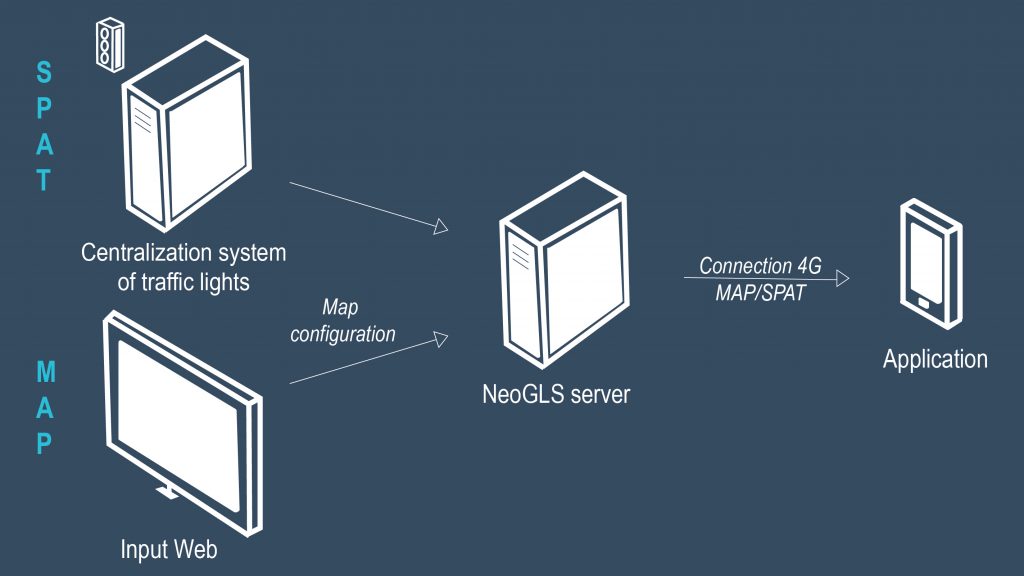
Solution 3:
- NeoGLS proceeds to the seizure of the map on the server by using the Web-based interface.
- The server receives the data concerning the current state of the traffic lights (color and duration), from the centralization system of the traffic lights.
- The server transmits these data to the Android application.
- Then, the application advises the driver.
C-The Difference Bordeaux
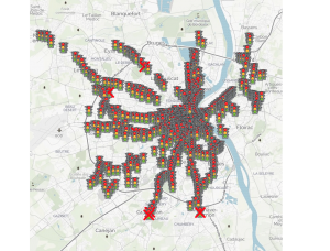
The GLOSA service is currently in application on the metropolis of Bordeaux, in the form of an application intended for the general public and freely available on Android smartphone. It’s directly connected to the system of centralized management of the traffic lights of Bordeaux: Gertrude.
The service provided by the app C-The Difference is deployed on more than 589 intersections in Bordeaux urban area (around 2300 traffic lights). The deployment of the service is still going on today in order to cover most of the intersections with traffic lights in the urban area.
The application gives the drivers a new way to handle the driving in the city thanks to the road infrastructures information he is given. It especially allows him to adapt his driving when getting close to an intersection managed by traffic lights.
An application intended for the general public to solve problems of urban mobility while respecting the fluidity of the traffic, the safety of the users, but also the impact on the environment.